I posted my first take at a small-scale regional map awhile ago, with 1 hex equal to 10 miles. Although very, very far from complete, it gave me the basic frame so that I could work on a larger-scale, one where 1 hex equal 2 miles. This map is centered on the City-State of Hajal, which is going to be the Lankhmar/Sanctuary/Tyr/whathaveyou of the Kahira setting.
Alert-eyed imaginary readers will note that I have already substantially changed the geography from the earlier effort--Hajal is on the other side of the great valley now.
Anyway, here's what we gots so far:
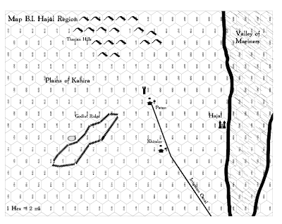
Alert-eyed imaginary readers will note that I have already substantially changed the geography from the earlier effort--Hajal is on the other side of the great valley now.
Anyway, here's what we gots so far:


I have some questions:
ReplyDeleteWhat software are you using?
Where did you get the numbered hex grid?
Thanks in advance.
I use Adobe Illustrator to make my maps. There may be better ways to do it, but it's the software I'm confortble with.
ReplyDeleteAnd I have been wracking my brains to figure out where I got that hex-map because I want to try and find one that has the numbers oriented properly for landscape. I just can't recall at all.
Anybody?
Matthew, check out HEXGRID UTILITY on the Planet Algol sidebar, custom numbered hexes!
ReplyDeleteI know that I tried that program, but there was something I din't like. Darned if I recall now. In the interim, I went and created a hex-map directly in Illustrator. So my map looks much better now that the one atatched to this post. I'll post the update soon.
ReplyDeleteSideways hexes disorient me :/
ReplyDelete