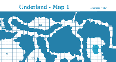
Obviously, still distracted. I have finally, finally finished the first map for Underland. As I said before, I can't post the whole thing because I have player's going through it, but I break down now and post just a snippet so the old-schooliness of the thing can be seen.


How do you make these maps?
ReplyDeleteI ask because I have a number of hand-drawn maps for a current project which I would love to do up in TSR Blue. But I can't find any sort of tutorial explaining the process for, well, any software.
I presume that a vector-based drawing program, an alpha fill, and multiple layers (grid/key/walls, at least) are requisites. But a short tutorial would be most helpful.
Adam
My first comment! Huzzah!
ReplyDeleteHi Adam.
There is probably a cleverer way to do them than I do (I suspect that Joe Bardales did the Mad Archmage maps seen at http://greyhawkgrognard.blogspot.com/2009/03/castle-of-mad-archmage-poster-maps.html smarter than I did).
But, I did indeed do what you suggest. I started with a hand-drawn map and scanned it. Then I placed it into Adobe Illustrator and used the auto-trace feature. That was the easy part. It took me forever to find the right shade of blue to colour that lines. For the record, in CMYK I used C 87.06%, M 23.53%, Y 8.63%, and K 1.53%.
Once that was done, I spent a good while fiddling with the lines and filling in the background. Then I drew in the symbols and numbers using Soutane Bold font, which nicely matches the old TSR modules.
At the end, I realized that my graph paper that I had downloaded looked awful, because the map. So I just drew up a new one, which was boring and time-consuming, but the effect is much better.
If you have Illustrator, I'd be happy to give any more specific tips. I was actually playing the idea of posting some kind of tutorial, if there was enough interest in it.
I learned quite a lot doing it and I think that the next one will be much faster than this first one.
I do have access to Illustrator, but I don't know how to use it very well. I would love to see a tutorial. Hopefully it's more than just me that's interested.
ReplyDeleteAdam
I'll see what I can do. Maybe I'll do a step-by-step on the blog as I do Map 2.
ReplyDeleteMatthew,
ReplyDeleteNice map, I look forward to seeing more — I do my own maps much the same way. A tip: if you take advantage of Move (to copy) plus Duplicate (command-D) you can do up a graph of any custom size that you want in a matter of minutes. Start with a square the size you want, Move (to copy) horizontal the width of the square. Hit command-D and this will duplicate the square as many times as you need. Then select all of your squares and do the same thing vertically with the whole row. Graph complete.
That's clever. Did you draw the hills and mountains on your Erimia map free-hand and trace them, or did you draw them in with the Pencil or Paintbrush?
ReplyDeleteI drew them freehand, scanned them, and then made them vector. That way they can be easily tweeked, resized, and duplicated.
ReplyDelete